Nanadinh
Oct 17, 2017
Writing Feedback / The developments of West Park Secondary School, from 1950 when it was erected, to 2010. [2]
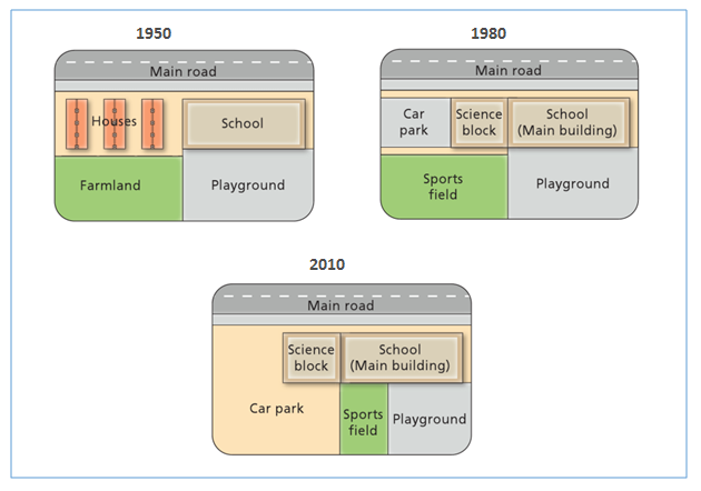
The maps illustrate the developments of West Park Secondary School, from 1950 when it was erected to 2010.
It is clear from the maps that the biggest change that happens at the school was that residential areas and farmland were demolished to make way for car park. At the same time, the school building was expanded with the construction of science block.
In 1950, school was built to the south of the main road and to the east of houses area. In 1980, car park, science block and sport field were constructed and replaced all houses and farmland.
From 1980 to 2010, there were huge changes in WPSS. Sport field was relocated to the east and was narrowed, while the place for parking was extended. So, at 2010, car park was the place accounted for about a half of WPSS.
In addition, playground was always located at the northeast corner of WPSS. However, it became smaller because of the construction of sport field.
Writting test 1 ielts. Maps
The maps illustrate the developments of West Park Secondary School, from 1950 when it was erected to 2010.
It is clear from the maps that the biggest change that happens at the school was that residential areas and farmland were demolished to make way for car park. At the same time, the school building was expanded with the construction of science block.
In 1950, school was built to the south of the main road and to the east of houses area. In 1980, car park, science block and sport field were constructed and replaced all houses and farmland.
From 1980 to 2010, there were huge changes in WPSS. Sport field was relocated to the east and was narrowed, while the place for parking was extended. So, at 2010, car park was the place accounted for about a half of WPSS.
In addition, playground was always located at the northeast corner of WPSS. However, it became smaller because of the construction of sport field.

Academic_IELTS_Writi.png
