Mia33109
Jul 30, 2018
Writing Feedback / The two maps depict the land-use changes on an island. IELTS TASK 1 [2]
Hello, i'm preparing for ielts test and looking for some feedback about my writing. I will appreciate If you are willing to leave me some comments.
Question:
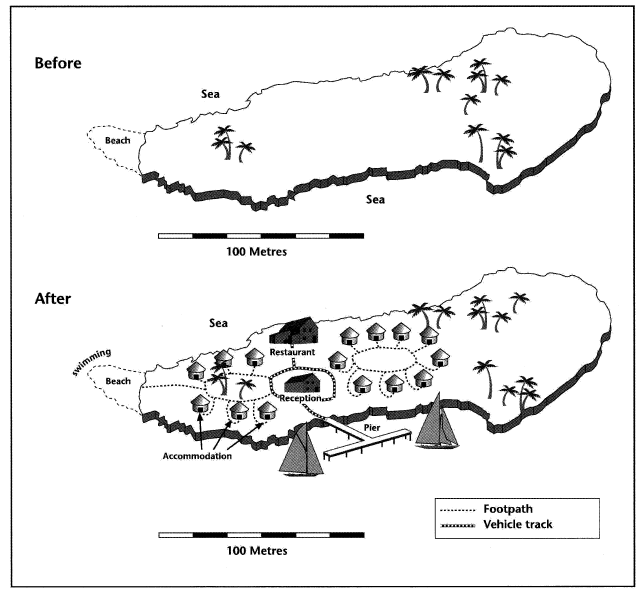
The two maps below show an island, before and after the construction of some tourist facilities.
Summarise the information by selecting and reporting the main features, and make comparisons where relevant.
Answer:
The two maps depict the changing of landuse on an island. Overall,it is clear from the graphs that there are more building of tourist infrastructure and a pier giving visitors access to the island after construction.
According to the proportional scale, the island was approximately 100 metres wide and 200 metres long. There was none of physical facilities built with only a few tress growing on the island and a beach extending from the west coast.
After planning and reconstruction, the island has been transformed into a scenic spot with a reception surrounded by vehicle track, connecting it to a restaurant in the north and to a pier on the south-coast island. In addition, there were some residences located on both side of the reception. Each housing were linked to a footpath forming a circle in the middle, and on the left side of residence, there was an extra path connecting to a beach available for swimming use on the western tip of the island.
Besides the developmental changes,it is also obvious to note that the eastern part of the land still remain undeveloped.
Hello, i'm preparing for ielts test and looking for some feedback about my writing. I will appreciate If you are willing to leave me some comments.
in maps - construction of some tourist facilities
Question:
The two maps below show an island, before and after the construction of some tourist facilities.
Summarise the information by selecting and reporting the main features, and make comparisons where relevant.
Answer:
The two maps depict the changing of landuse on an island. Overall,it is clear from the graphs that there are more building of tourist infrastructure and a pier giving visitors access to the island after construction.
According to the proportional scale, the island was approximately 100 metres wide and 200 metres long. There was none of physical facilities built with only a few tress growing on the island and a beach extending from the west coast.
After planning and reconstruction, the island has been transformed into a scenic spot with a reception surrounded by vehicle track, connecting it to a restaurant in the north and to a pier on the south-coast island. In addition, there were some residences located on both side of the reception. Each housing were linked to a footpath forming a circle in the middle, and on the left side of residence, there was an extra path connecting to a beach available for swimming use on the western tip of the island.
Besides the developmental changes,it is also obvious to note that the eastern part of the land still remain undeveloped.

ieltsmap50island.png
