harryvn
May 17, 2023
Writing Feedback / The maps below show an industrial area in the town of Norbiton, and its planned future development [NEW]
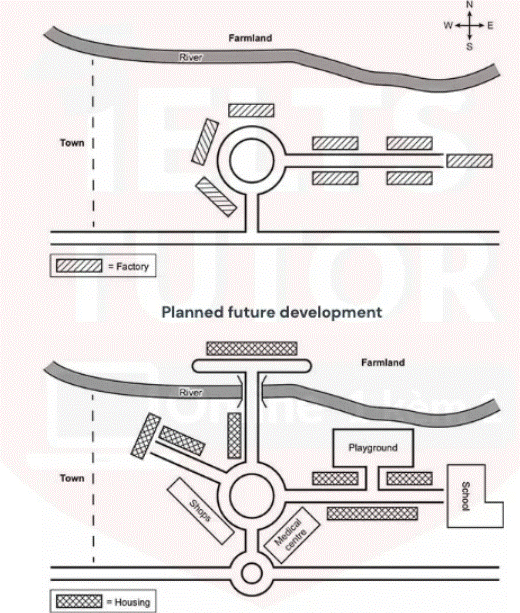
The graphics illustrate how the industrial park of Norbiton town will be changed for development in the future.
Overall, the town is expected to be a mainly residential landscape with several housing units and public facilities, especially factories will be removed, and the road system will be expanded.
Looking first at the current map, the town where it is located has a land farm along the north and a river running east from the west and a road in the south of town. In the centre of the area, outside the east of town, there is a street connecting eight factories and only one roundabout. Three factories concentrate near the roundabout, while five factories are along the road in the eastern.
In the future, there will be a massive change in the area where the factories will be removed. In the north of the town, a residential and short road will be constructed, and a bridge that connects to the mainland will be installed. In the south, a small roundabout will be added to link with a main street and a large roundabout, while a road will be newly established to connect the bridge in the north and one residential in the left of the street. In the centre of the outskirts of town, starting the roundabout, a new road will be constructed in the northwest and will be built two residential areas. Besides that, the shops and medical facilities near the roundabout will be created on the south of the roundabout. Finally, five factories will be converted into three housing units, a playground north of the street, and a school at the end of the road.
planned future development
The graphics illustrate how the industrial park of Norbiton town will be changed for development in the future.
Overall, the town is expected to be a mainly residential landscape with several housing units and public facilities, especially factories will be removed, and the road system will be expanded.
Looking first at the current map, the town where it is located has a land farm along the north and a river running east from the west and a road in the south of town. In the centre of the area, outside the east of town, there is a street connecting eight factories and only one roundabout. Three factories concentrate near the roundabout, while five factories are along the road in the eastern.
In the future, there will be a massive change in the area where the factories will be removed. In the north of the town, a residential and short road will be constructed, and a bridge that connects to the mainland will be installed. In the south, a small roundabout will be added to link with a main street and a large roundabout, while a road will be newly established to connect the bridge in the north and one residential in the left of the street. In the centre of the outskirts of town, starting the roundabout, a new road will be constructed in the northwest and will be built two residential areas. Besides that, the shops and medical facilities near the roundabout will be created on the south of the roundabout. Finally, five factories will be converted into three housing units, a playground north of the street, and a school at the end of the road.

Screenshot2023051.gif
