HuongTruong
Jan 4, 2021
Writing Feedback / The maps below show the town of Langley in 1910 and 1950. Summarise the information [2]
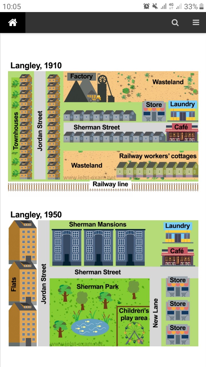
Langley town has been flourished from 1910 to 1950. The town house along Jordan and Sherman street are removed, local people now live in the Flats in the left side of Jordan street. On the areas of old Factory, the Sherman Mansion was built. The new street connect Sherman street and the removable old Rail Way line was built name New Land. On the right side of New Land there are three new stores and the old store at Sherman street was destroyed. With the development the old Rail way and also the rail way worker cottages were removed. On that area they built the Sherman park which has the children's play areas on the New Lane side opposite to the stores. The café moved to the opposite, next to the Mansion on Sherman street. The Laundry was rebuilt behind the café. Within 40 years Langley town developed quickly from a countryside with a large wastes land due to factory to a modern town with more recreational facilities.
Describe information in a map
Langley town has been flourished from 1910 to 1950. The town house along Jordan and Sherman street are removed, local people now live in the Flats in the left side of Jordan street. On the areas of old Factory, the Sherman Mansion was built. The new street connect Sherman street and the removable old Rail Way line was built name New Land. On the right side of New Land there are three new stores and the old store at Sherman street was destroyed. With the development the old Rail way and also the rail way worker cottages were removed. On that area they built the Sherman park which has the children's play areas on the New Lane side opposite to the stores. The café moved to the opposite, next to the Mansion on Sherman street. The Laundry was rebuilt behind the café. Within 40 years Langley town developed quickly from a countryside with a large wastes land due to factory to a modern town with more recreational facilities.

z2261441902255_f6983.jpg
