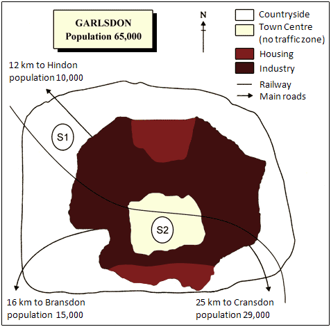
The below scheme shows a detailed map of Garlsdon Town with its relations to different industrial and residential sectors and facilities, and 2 proposed locations for eventual supermarket in this town.
According to the map, the S1 site situated in the peripheral rural area of the town, while S2 site in Garlsdon town centre within a no traffic zone area.
S1 site is in proximity of Hindon city in its 12 km distance and 10000 populations, while the S2 site is in a way of Cransdon in its 25 km distance and Bransdon in its 16 km distance. The population for the Cransdon and Bransdon is 29000 and 15000 persons, respectively.
While the S2 site is situated in the half through way of the 2 main industrial zones in the Garlsdon town, the S2 site is close to one of these zones.
There is a main railway, which passes through the Garlsdon town, and both S1 and S2 sites have the same remoteness to this railway.

Map of Garlsdon
