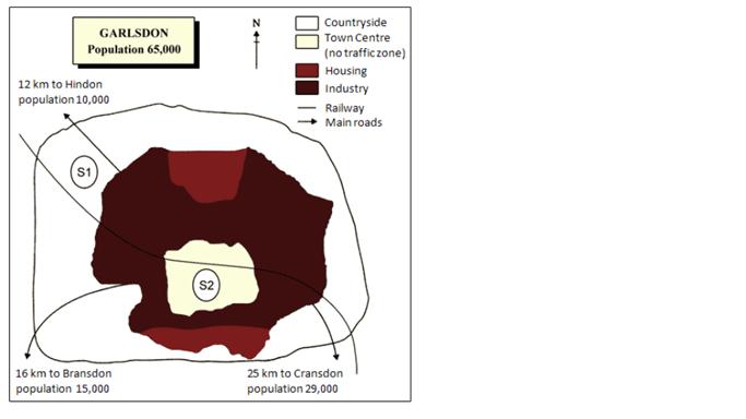
The map below is of the town of Garlsdon. A new supermarket (S) is planned for the town. The map shows two possible sites for the supermarket.
Summaries the information by selecting and reporting the main features, and make comparisons where relevant.
The map shows the town of Garlsdon. Program of this town is building a new supermarket (S). The supermarkets have two potentially located.
In general, located for build new supermarkets are crossed over by railway and main roads. It has a few cities which is of 65,000 population appears in the map.
The located of S1 is in the countryside. It is more restful because it has long distance from industrial areas. Because of this area placed in suburbs between railway and highway to Hindon (12 km with 10,000 population), there is easier to people visited by transportation.
Moreover, the recommended location of S2 for supermarket is in the town center. In the map, there are two housing area in north side and south side. The highway is also to connect from Cransdon (25 km with 29,000 population) to Bransdon (16 km with 15,000 population). Although this area is industrial area, there is no traffic-zone in here.
Overall, both of two areas are able to build supermarket and people could use transportation to this area.

Garlsdon.JPG
