septyndid
Mar 27, 2017
Writing Feedback / Change in town - the alteration of Stokeford village in 1930 and 2010. [4]
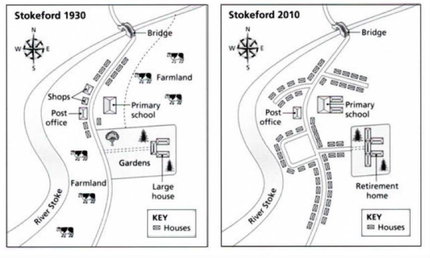
The maps below show the village of Stokeford in 1930 and 2010. Summarise the information by selecting and reporting the main features, and make comparisons were relevant.
The map illustrates about the changes of Stokeford village in 1930 and 2010. It can be seen that in 1930, there was some farmland areas in the east and west of the main road, but the condition turned into housing estates in 2010.
The first location of village changes was in the west of the main road. In 1930, there was a river stroke in the western village, which run from the south west to the north east of village. This river still existed in 2010 with the same location. Between river and main road, there were large farmland areas in the south of post office, but it has been changed into houses. Also, in the north site of post office, there were shops that close the office in 1930, but these buildings were turned into houses and small road in 2010.
The village changes also occurred in the east of the main road. There was a small primary school in front of post office and it was expanded in 2010. In the south of school, there were a house, gardens, and a large house. The garden became housing estates and it developed along the main road, also the large house had been expanded into a retirement house. In the north of school, the farmland areas had been changed into houses and there was also a small road in 2010.
The maps below show the village of Stokeford in 1930 and 2010. Summarise the information by selecting and reporting the main features, and make comparisons were relevant.
describing changes in stokeford
The map illustrates about the changes of Stokeford village in 1930 and 2010. It can be seen that in 1930, there was some farmland areas in the east and west of the main road, but the condition turned into housing estates in 2010.
The first location of village changes was in the west of the main road. In 1930, there was a river stroke in the western village, which run from the south west to the north east of village. This river still existed in 2010 with the same location. Between river and main road, there were large farmland areas in the south of post office, but it has been changed into houses. Also, in the north site of post office, there were shops that close the office in 1930, but these buildings were turned into houses and small road in 2010.
The village changes also occurred in the east of the main road. There was a small primary school in front of post office and it was expanded in 2010. In the south of school, there were a house, gardens, and a large house. The garden became housing estates and it developed along the main road, also the large house had been expanded into a retirement house. In the north of school, the farmland areas had been changed into houses and there was also a small road in 2010.

map_3.jpg
