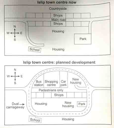
Islip before and after development
The maps below show the centre of a small town called Islip as it is now, and plans for its development.
Summarise the information by selecting and reporting the main features, and make comparisons where relevant.
The two maps illustrates the town center of Islip before and after the development. The map above is today's Islip town center, while the bottom is development plan of town center.
Nowadays, a main road crosses the town center from east to west. However, it will be replaced as a pedestrian walkway in the future plan. A dual carriageway, which goes around the town center, will be the new main road.
All of the shops in town are situated on the both sides of the main road. In new development, the shops and the countryside on the north side will be replaced by some facilities, including bus station, shopping center, car park and new housing. Shops on the south will remain the same.
On the south of Islip, new housing will be constructed near the area near the park in the east. On the west side of the housing area, it will not affected by the planned development. Both school and park will be connected with the dual carriageway.

1.jpg
