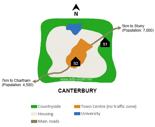
Two possible locations for school in the town of Canterbury are planned on the map. Overall, it can be seen that the first school is located in the countryside, far from the Town Centre, while the second is planned in the Town Centre which is surrounded by the people's house.
Rural area as the first possible location to construct a new school is far from the countryside, exactly in the East of black houses. It needs 5km to travel from city center to Sturry. If it is built here, it will be near by Sturry which has 7,000 inhabitants, thus provide an easy access for the countryside people, especially the Sturry's people.
The second option, the school is predicted to be built in the middle of the town center surrounded by a large housing in the west of the university. If it is truly happen, all of the people of Canterbury will be easy to access it, even though there is a 7km distance from town to Chartham, which has 4,500 inhabitants, but there is a main road to connect these areas.

IELTS_Writing_Map_14.png
