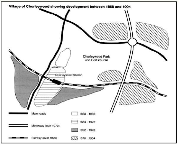
The given diagram depicts the various infrastructural developments and the improvement of area around Chorleywood Park and Golf Course during 1868- 1994 in chorleywood Village.
Firstly,in 1868-1883, a place of a nearly pear shaped white portion was under development which is towards the West end of Cherlywood Park and Golf Course. In the following 1883-1922 period, Chorleywood Station was constructed which was in horizontal lines area at the west end of Park and it extended towards south region. In a similar way, the place around Chorleywood Station which is in black shade was improved during 1922-1970. On the other hand, massive developments occurred in the north and east side of Park between 1970 and 1994 which appears in vertical lines.
Secondly, the various modes of transportation made the Chorleywood Park into a square shape. The Main Roads became the north and west boundaries while Motorway which was established in 1970 ,goes along the eastern side. Finally, Rail track was constructed in 1909 and it extends throughout the southern boundary of Chorleywood Park.
In conclusion, I believe that Chorleywood Park and Golf Course are reachable by all modes of transportations and all sides of the park were being improved with facilities except the North-West region.
Please correct my essay.
Thanks very much.

224110_1_o.jpg
