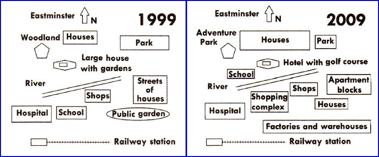
An illustration of the development in the Eastminster over a decade, from 1999 to 2009, is depicted in the presented maps. Overall, it can be seen that several new buildings were constructed on the southeast side of this town during a 10-year period, while across the river, on the northwest side, several business sectors were also established.
Looking at the southeast side, private houses were reduced tremendously which were altered to be apartment blocks. The hospital and small shops remained unchanged alongside the river. Similarly, railway station still settled on the west of the town. Unfortunately, the school was relocated and replaced by shopping line, and the replacement of public garden into factories and warehouses made this urbanised area.
In the northwest position, Woodland was developed into Adventure Park. It is noticeable houses in this neighbourhood became larger, while the park adjacent to them became less spacious than those in the past ten years. A particular distinction has been noted, it was a hotel featured with golf field standing in place of a mansion with gardens. A new school also has been built next to the hotel.

Task_1Map.jpg
