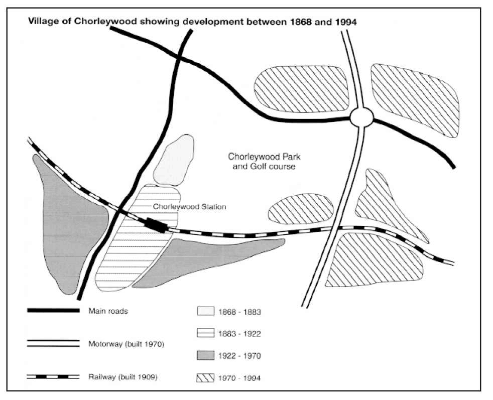
Chorleywood is a village near London whose population has increased steadily since the middle of the nineteenth century. The map below shows the development of the village.
Summarize the information by selecting and reporting the main features and make comparisons where relevant
A map illustrates how the village of Chorleywood developed between 1868 and 1994. The process is divided into four phases: 1868-1883, 1883-1922, 1922-1970 and 1970-1994. The change during each phase will be summed up in this essay and comparison made whenever necessary.
Overall, Chorleywood grew as the transport infrastructure improved. Beginning as a small settlement, the village came to comprise several populated areas close to the transport network. At the center of the map laid Chorleywood Park and a golf course, which went untouched over the more than one century.
Chorleywood originally occupied a humble-sized land, in proximity to the south-north main road to the west and the park and golf course to the east. During the second phase, it expanded south into a modest-sized settlement, along the road but never across it. In 1909, there emerged a railway and a station in Chorleywood. It cut through the village from west to east and indicated the direction of its development in the next phrase.
The settlement south of the railway further extended both west and east until 1970, when a motorway was built beyond the eastern tip of the village. Populated areas then began to appear around where the south-north way crossed the railway and one of the main roads. In this phase Chorleywood expanded much faster than ever, but the park and the golf course remained well-preserved.
I would more appreciate it if you score my essay.
Summarize the information by selecting and reporting the main features and make comparisons where relevant
Report on the Chorleywood village
A map illustrates how the village of Chorleywood developed between 1868 and 1994. The process is divided into four phases: 1868-1883, 1883-1922, 1922-1970 and 1970-1994. The change during each phase will be summed up in this essay and comparison made whenever necessary.
Overall, Chorleywood grew as the transport infrastructure improved. Beginning as a small settlement, the village came to comprise several populated areas close to the transport network. At the center of the map laid Chorleywood Park and a golf course, which went untouched over the more than one century.
Chorleywood originally occupied a humble-sized land, in proximity to the south-north main road to the west and the park and golf course to the east. During the second phase, it expanded south into a modest-sized settlement, along the road but never across it. In 1909, there emerged a railway and a station in Chorleywood. It cut through the village from west to east and indicated the direction of its development in the next phrase.
The settlement south of the railway further extended both west and east until 1970, when a motorway was built beyond the eastern tip of the village. Populated areas then began to appear around where the south-north way crossed the railway and one of the main roads. In this phase Chorleywood expanded much faster than ever, but the park and the golf course remained well-preserved.
I would more appreciate it if you score my essay.

QQez201707262139.png
