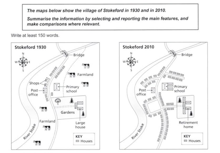
The maps compare the changes of village of Stokeford in 1930 and 2010. Overall, it can be seen that in the end of the period, there were much more houses had been built, overtook the farmland. Some buildings also changed structurally and functionally, but some of them did not show any change.
The most remarkable in this village's landscape was the lost of farmland which scattered in the early 19s century. The causes was the huge number of houses had been built on it. In the year 1930, the houses only presented in the northside of the village, alongside the mainroad, while farmland existed in south western and north eastern side. However, 80 years later almost all part of the village had been altered to residential area.
Over this 80-year period, there were some structures which experienced alteration and some were not. The large house in 1930 had been altered in function becoming retirement home, and the structure had been expanded both to the north and south sides with smaller gardens. Primary school in the north west of that building also witnessed building expansion in the end of this period. There was also construction of some streets forking to the north and east from the main road, and houses was built along its side so that there were several houses near the river. The shops which priorly existed near post office had been demolished in 2010. However, post office between the main road and the river, and the bridge which was connected the village with area in the north remained unchanged.

map_stokeford.jpg
