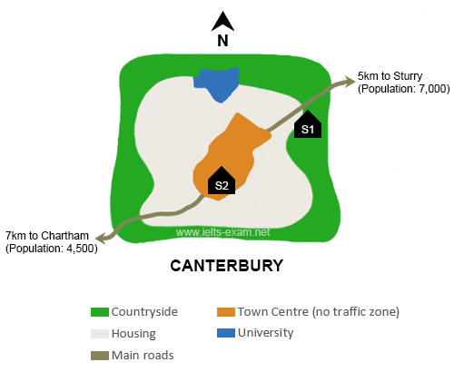
The map below is of the town of Canterbury. A new school (S) is planned for the area. The map shows two possible sites for the school.
Summarise the information by selecting and reporting the main features, and make comparisons where relevant.
The map depicts the city planning in the town of Canterbury where are connected with two areas; Chartham and Sturry. There are three public zones; educational facility and infrastructural public transportation. Overall, there are two strategic areas which will be built a new school in the town of Canterbury.
To begin, 5km is the distance from Sturry to planned site for S1 with 7,000 populations. S1 area is located between Housing and Countryside zone. Moreover, the university can be seen in the northeast of the S1 area and in the west there is Town Centre. The main road connects from Town Centre to Sturry.
In any case, planned area for S2 is situated in Town Centre which is no traffic zone. S2 area, which has a population of 4,500, lies 7km from Chartham and running along from the S2 planned area to Chartham is main road. This area is covered by Housing and Countryside zone and university is located in the north of S2 site.

Canterbury.png
