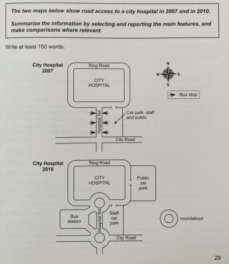
Road assess to a city hospital in 2007 and in 2010
The given maps illustrate several transformations on transportation infrastructures regarding the routes accessing to a city hospital between year 2007 and 2010.
Overall, there were three dominant adjustments conducted referring to vehicle access to the city hospital, including two added roundabouts, newly established bus station, and extra parking places.
It is evident that the previous combined parking lot provided for both the public and staff in 2007 was redesigned in 2010. The particular parking facility was divided into two individual sectors and made use by the citizens and hospital employees respectively. The staff car park was placed in front of the hospital building with the general public car park set on the side, each owning an entrance directly leading to the Ring Road and city hospital.
As is also observed, it was only available for people to drive or went on foot to city hospital back in 2007, while the newly constructed bus station contributed to an additional public transportation choice for the patients in 2010. In comparison to the simple pathways connection layout in 2007, the bus station was associated with two roundabouts located on Hospital Road, forming a transportation hub to disperse the car flow.

Task1_map.jpg
