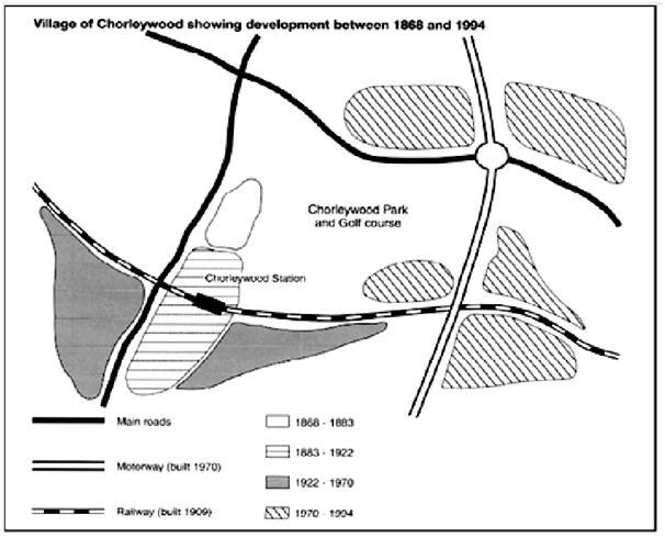
Chorleywood is a village near London whose population has increased steadily since the middle of the nineteenth century. The map below shows the development of the village.
Write a report for a university lecturer describing the development of the village.
I hope you will help me correct my essay! I appreciate all your feedback!
The map provides information about the growth of Chorleywood, a village located near London, from the late 1860s to the mid 1990s. Overall, there was a close connection between the rise in the population of the village and the traffic networks, both of which underwent noticeable enhancements throughout the period.
From 1868 to 1883, Chorleywood originally consisted of a small community to the west of the Chorleywood Park and Golf Course. Besides, it was sited next to a North - South routeway, which was one of the two main roads available at that time.
Over the next four decades, the village commenced its expansion to the south, which nearly tripled its initial size. In 1909, the infrastructure was strengthened by the new additional railway that was built across the small town as well as the establishment of Chorleywood Station.
Furthermore, the third period, from 1922 to 170, saw a continuos enlargement both eastwards and southwards of the village along the rail road.
Following that, there was a marked improvement of the transportation networks when a motorway was built in 1970. By 1994, the villagers had extended their area around the junctions between the newly completed motorway and the two East - West traffic lines.

IELTSwritingtask1.jpg
