Hi, all. This is the third times I write in the same map, it does not matter for me to write same prompt repetitively, in order to increase my understanding.I am glad that all of you deign to compare my two previous.
======================================================
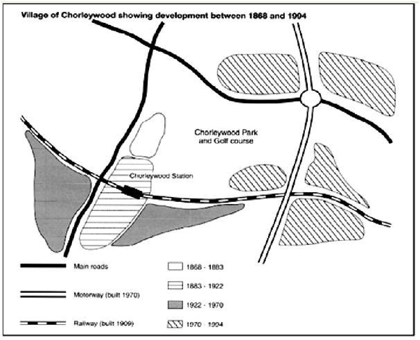
The given map reveals the information regarding the developing of Chorleywood village in 126 years started from 1868 to 1994.
Overall, while three transportation accesses were built between 1909 and 1970, the four areas in Chorleywood, shaped in the legend, also built consecutively.
Turning to the details, started from 1868 to 1883 a small area appeared nearly Chorleywood Park and Golf course while horizontally shaded area, built between 1883 and 1992, constructed around Chorleywood station. Next, by comparison with the two darkly shaded areas which were established in the west corner and south-east station, the newest area showed tremendous developed in almost center and east of village.
A more detail looked at the transportation accesses. By comparison with Railway and Motorway, number of main roads quantitatively showed in the north and west side of map. On the other hand, the length of railway connecting west-to-east side of village built in 1909 while the motorway connecting north-to-south appeared in 1970.
Interestingly, the centre of village showed the highest rate of development from 1868 to 1883 and from 1970 to 1994.

chorleywood.jpg
