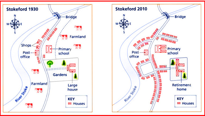
The developments of Stokeford, a riverside town, in almost a decade starting from 1930 to 2010 are displayed in the map. The most highlighted difference is a massive reduction of farmlands which were replaced by houses with several additions of roadways.
In 1930, farmlands existed in the west and east side of the town and a primary road leading from the south to a bridge in the north. In addition to this, a large house and gardens were located in the middle of the town, connected to the road and a path spotted behind primary school and going through farmlands to the north east, but over a 80-year period, these were altered into retirement home surrounded by fewer trees and facilitated with new roadway. Opposite side of this showed plenty of houses as the most part in the center to the south of the city in 2010, which was occupied by farmland in 1930.
The northern side would share the same fate, as houses predominantly filled the area. This caused no remaining farmland in this city. Other housing complex, with a road running into riverside, was constructed in place of the shops, next to post office. In the northern east of Stokeford, the path and farmlands were also replaced by some houses. Interestingly, primary school became larger, while no changes occurred in the river stoke and the bridge.

Map
