norbiton industrial area now and in the future
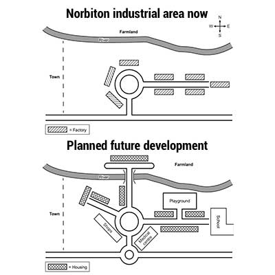
The maps illustrate an area industrialized with factories in the town of Norbiton and a design for future upgradation of the site. Overall, there is expected to be a construction of accommodations with other community facilities for villagers.
To begin with, all the town factories are planned for demolishment to make place for the modification. The primary one is the development of the transportation system, which constructed extra road branches from the big roundabout to the east and north sigh of Norbiton town. In the north of Norbiton, there will be an erection of a bridge crossing the river, while a small roundabout will be built at the T-junction in the south of the town.
Consequently, the construction of accommodations is planned to conduct along the road branches. Besides housing area in the internal, the town is predicted to have a dwelling area next to the farmland to the north of the river which is crossed by the north route. Additionally, a school at the end of the west route is planned to establish in the future development to serve students in the town. Between the river and the housing area on the west, there will be an establishment of a playground which is connected by a path from the west road. Finally, a shopping center and a medical center are predicted to be constructed to the southeast and southwest of the main roundabout respectively.

themapsbelowshow.jpg
