Hi! I would love to see comments based upon IELTS marking criteria, and possibly a detailed band score!
Thank you!
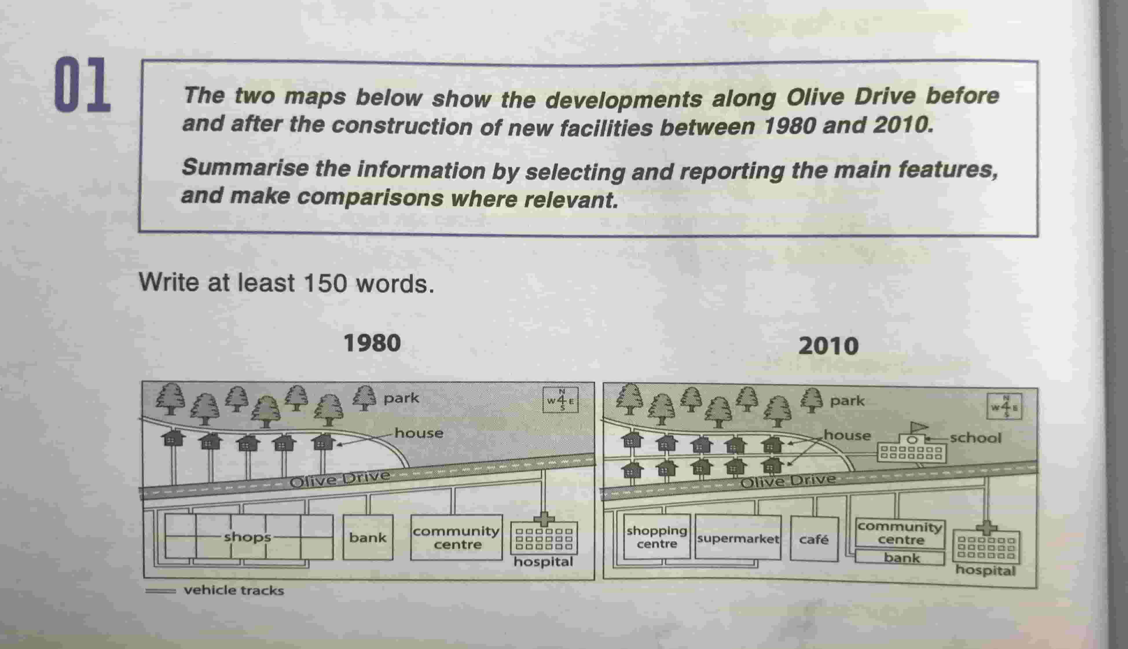
TASK 1 (Maps): The two maps below show the developments along Olive Drive before and after the construction of new facilities between 1980 and 2010.
WORD COUNT: 174
The two maps provide information on how areas along the Olive Drive changed by comparing the years of 1980 and 2000. This area had grown larger in residential capacity and offered many new businesses. Overall, it is clear that more housing units and retail establishments were built.
As compared to 1980, the community had 5 more houses, in the same areas with the old ones, located along Olive Drive. The most significant difference to the town was the removal of the shopping compound; a shopping center and a supermarket replaced its place. Next to the new buildings, the old bank now transformed into a café. Furthermore, a new school was constructed in the unused land to the northeast of the map.
Other areas around the Olive Drive had little changes. Some more vehicle tracks emerged to support internal traffic. Only the community center shrank in size to share the space with a small bank in the southern direction. Next to them, the hospital and the park in the north of the map remain unchanged.
Thank you!
TASK 1 (Maps): The two maps below show the developments along Olive Drive before and after the construction of new facilities between 1980 and 2010.
summarise the information
WORD COUNT: 174
The two maps provide information on how areas along the Olive Drive changed by comparing the years of 1980 and 2000. This area had grown larger in residential capacity and offered many new businesses. Overall, it is clear that more housing units and retail establishments were built.
As compared to 1980, the community had 5 more houses, in the same areas with the old ones, located along Olive Drive. The most significant difference to the town was the removal of the shopping compound; a shopping center and a supermarket replaced its place. Next to the new buildings, the old bank now transformed into a café. Furthermore, a new school was constructed in the unused land to the northeast of the map.
Other areas around the Olive Drive had little changes. Some more vehicle tracks emerged to support internal traffic. Only the community center shrank in size to share the space with a small bank in the southern direction. Next to them, the hospital and the park in the north of the map remain unchanged.

IMG_3197min.JPG
