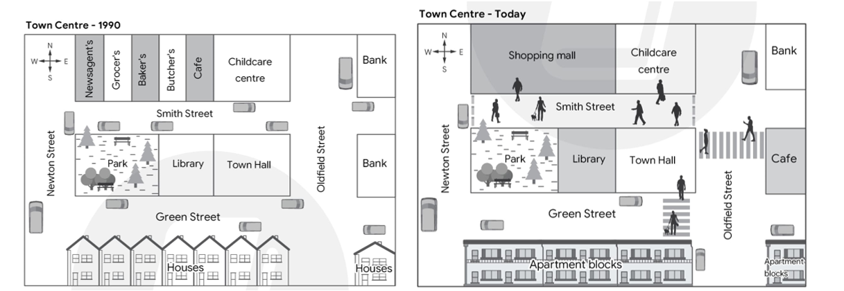
Topic: The maps below show a town centre in 1990 and the same town centre today. Summarise the information by selecting and reporting the main features, and make comparisons where relevant.
Greetings everyone, I've just finished writing this essay and would really appreciate some feedback and a sample band score. I am grateful for your assistance!
_______________________________________________________________________________
These two maps present the transformation of a town center in a 34-year period starting in 1990.
In general, these two layouts exhibit a stark contrast in features, with antiquated decoration initially, and additional amenities after development.
In 1990, the town center had a layout designed for driver convenience, with clearly visible arrangements. At first, there were two rows of houses directly connected to Green Street, which was one of the main roads of the town center. The other main streets included Newton Street, Smith Street, and Oldfield Street, arranged clockwise. Additionally, on the east side, there were two banks on Oldfield Street, opposite an entertaining area, which contained a childcare center, café, butcher's, et cetera. Finally, in the middle of the picture was the location for a park, library, and town hall, but there was no cross-hatching from any sides of the road.
Today, it has undergone a complete alteration, with modern facilities added to enhance the comfort and convenience of residents. In detail, two initial parallel housing areas have been updated to become apartments, with a designated crosswalk leading from the flat to the remaining positions including town hall, library, and park. However, while the bank with a frontage on Smith Street and Oldfield Street remains, the opposite side has been replaced with a coffee shop, which is now connected to the town hall via a zebra crossing. Moreover, only the childcare center stays in the same place, but five stores next to it have been demolished to build a shopping mall on Smith Street, which has been converted into a pedestrian precinct.

Screenshot2024060.png
