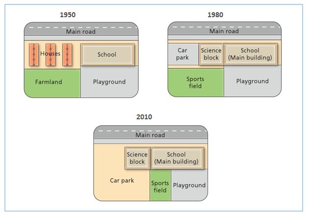
The diagrams show the changes that have taken place at West Park Secondary School since its contraction in 1950.
----------------------------------------
The maps compare the difference of West Park Secondary School buildings arrangement in 1950, 1980 and 2010. Overall, the school area had been expanded immensely. There are also several structures which had been built or demolished.
The area of the school block had been widen in 1980, two times from its size when it was constructed. Originally, in 1950 there was only one main building which was faced the main road, in the left side of it there were three houses. The school also had playground area behind main building, in the right side of farmland. However, in 1980 the school began to expand to the left side, overtake the area of houses and farmland.
Over the 6-decade period, some area had been altered structurally and functionally. In 1980, the houses had been demolished, then half of its area is used for parking car and the other half area between it and main building used for a science block . Meanwhile, farmland had become sport field in that year. Furthermore, in 2010 the car park are expanded over the prior sports field. Because of that, the sports field was moved to one-third part of playground, so that it was located between smaller playground and wider car park.

road_map.jpg
