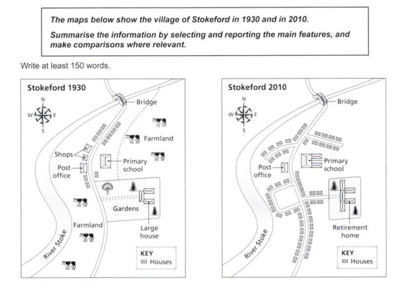
The maps below show the village of Stokeford in 1930 and in 2010.
Summarise the information by selecting and reporting the main features, and make comparisons where relevant.
The maps illustrate the changes that have been occurred in countryside of Stokeford over 8-decade period beginning in 1930 and ending in 2010. The most noticeable alterations were green areas on north and west side of the village.
To begin, from 1930 to 2010 the major changes at this countryside was infrastructure and residential. On the north east, farmland had been replaced with residential while primary school was enlarged. Meanwhile, large house that was placed on the east in 1930 was constructed as retirement home in 2010. Also, at the same time the houses were built in front of the retirement home and it was replaced an open area.
In addition, there was big difference between 1930 and 2010 which the number of its population was increasing. On the south west, green area which used to a farmland had been constructed as a residential landscape and there was a new pavement road in the middle of the village. The domestic houses were located along through this road while there was also a new road beside post office to replace shops building in 1930 on the north west. The most recognizable changes were farmland and roads during the period.

MAP2.jpg
