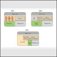
West Park Secondary School map. The building experienced a significant change from 1950 to 2010.
The three diagrams below illustrates the development of West Park Secondary School Area, since it was built in 1950. Overall, we can see from the diagrams that there were several changes in open area, for instance farmland, sport fields and playground.
In 1950, school area located besides residents area with farmland and playground were behind those buildings. For the next thirty years, West Park Secondary School expanded its area by adding car park and science block building at the places where citizens' houses used to be there. In the same years, the sports field had been built next to the playground. Farmland were not exist anymore in 1980.
Three decades later, needs of parking lot were increased and took a whole park of sports field for its expansion. Therefore, place where students play with their peers became narrowed, because of a half of its area had been built for the sports field.

280128_1.jpg
