Islip centre now and in the future
TOPIC
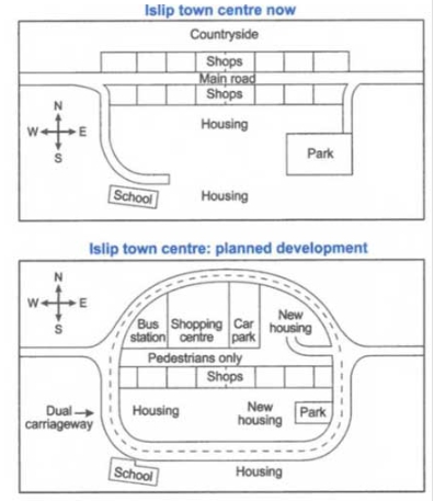
The maps below show the centre of a small town called Islip as it is now, and plans for its development.
My Answer.
These diagrams illustrate the present layout of the center of a town named Islip and the future plan of it.
It is clear that a dual carriageway will be built to surround the shops and the north shops will be modified into four different kinds of areas, like bus station, shopping center, car park and new housing.
As you can see in the first picture, there is a main road between the both sides of shops, people can go shopping, park, school and houses by this main road. However, it will become a road for pedestrians only in the future. Instead of the main road, a new dual carriageway will be built to connect park, school, housing and so on.
The shops on the north side of the town will be added other functions. The shops only retain the central part, both side of the shopping centre are bus station and car park respectively. New housing will be placed on the east side of the car park. Also, there will have another new housing on the west side of the park.

I wrote article according to this picture
