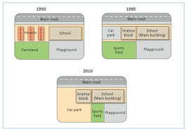
transformations at West Park Secondary school
The maps illustrate the transformation of areas surrounding West Park Secondary school in a 60-year period.
Overall, school area was enlarged main while playground was contracted in the same period. In addition, big chances were witnessed in other fractures including houses, car park, farmland, science block and sports field.
As was shown in the maps, main road which is next to school was not change in period surveyed. In contrast, house was replaced with car park and science with similar size. School to the right of the houses was extended in 1980 and was remained through 30 years later.
In 1980, sports field was constructed right on the site where the farmland used to be. However, Car park increased in size and took whole area of old sports field in 2010. Subsequently, a part of playground which was in the right bottom was corner was used to built a new sports field. Therefore, there was a decline in terms of size of the playground.

Task1_map.png
