IELTS WRITING - TASK 1 - DEVELOPMENT OF STOKEFORD VILLAGE
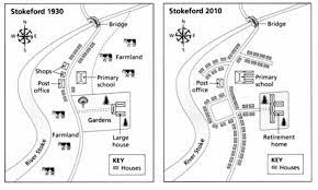
The maps below show the village of Stokeford in 1930 and 2010.
Summarise the information by selecting and reporting the main features, and make comparisons where relevant.
The diagrams illustrate how the village of Stokeford had changed over an 80-year period, from 1930 to 2010.
Overall, the village developed substantially over the course of 80 years with the increase of accommodation and infrastructure, resulted in the sacrifice of farmland areas.
As the first map reveals, Stockford village is located on the east bank of the River Stoke and in 1930, it was relatively undeveloped. There was a sole main road started from a bridge in the north with several houses on both sides. Additionally, the town center was also constituted by a primary school, a post office, some shops and a large house within gardens. Meanwhile, the areas in the northeast and southwest corners were deployed for agricultural purposes.
However, the village had growth dramatically by 2010. The farmland areas had been completely cleared to make way for more houses and roads construction. Similarly, the large house had been demolished and supplanted by a bigger retirement home, whereas the gardens surrounding it had reduced in size. Another development was experienced in the primary school, which had been upgraded with two additional buildings. On the other hand, the original bridge and post office had been intactly preserved throughout the given period.

download.jpeg
