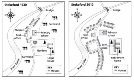
The two maps provide information regarding the noticeable change of the village in Stokeford between 1930 and 2010. Overall, what stands out from the maps describes that some new residence areas have been built in 2010. Meanwhile, in a particular location some building experienced renovation and footpath accesses have also been added.
According to maps, clearly, we can see that the village of Stokeford saw a profound transform in 2010. First, in a wide farm area in the village has developed many houses. In addition, there added some highway connecting house with each other houses, and then retirement home in apposite of east in the maps has also altered in 2010 such as garden was destroyed and retirement home replaced large house with decreasing a wide area of garden.
Moving to a more detailed analysis from the maps reveals that a change considerably also happened in public building. In 1930 there was one school building only but it has expanded in 2010. However, two buildings for shopping were demolished in 2010.

village_of_Stokeford.png
