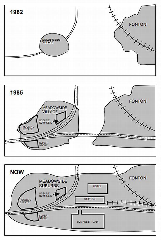
The maps illustrate how Meadowside village and Fonton, which is a neighboring town, have developed over three different time periods (1962, 1985 and the present).
Summarize the information by selecting and reporting the main features, and make comparisons where relevant.
Three maps are provided for analysis of the transformation in Meadowside village and the nearby town of Fonton. The time points chosen for the purpose are 1962, 1985 and the present. In this essay, I will summarize their developments in size and infrastructure, and make comparisons wherever relevant.
Overall, Meadowside and Fonton alike have undergone immense changes. They used to be completely separate but merge together as they both expand far beyond their original size. Initially as a village, Meadowside is converted to a suburb where a range of facilities are created.
In 1962, Meadowside was a small village in the west, located on a narrow road curving north to west. In contrast, Fonton was a town of modest size in the east end, situated on a railway winding north to east. This year, there was no transport route connecting Meadowside and Fonton, nor did any other facility exist.
In 1985, there was considerable growth in the size of Meadowside and Fonton. The road intersecting Meadowside was upgraded to a broader one, from which a new road branched off east to communicate it with Fonton. Around the convergence of these roads sprung up a leisure complex, a housing estate and a supermarket.
Currently, Meadowside, which is now a suburb, and Fonton have united as a result of further expansions. A new railway extends to the west where a station comes into existence. To its north is established a hotel; across the east-west road from the station lies a newly-built business park.
Though map comparison tasks are not common, I have to prepare for them that do appear the test. I try to develop my own style of map comparison writing.
I would more appreciate it if you score my essay.
Summarize the information by selecting and reporting the main features, and make comparisons where relevant.
transformation of Meadowside - analisys
Three maps are provided for analysis of the transformation in Meadowside village and the nearby town of Fonton. The time points chosen for the purpose are 1962, 1985 and the present. In this essay, I will summarize their developments in size and infrastructure, and make comparisons wherever relevant.
Overall, Meadowside and Fonton alike have undergone immense changes. They used to be completely separate but merge together as they both expand far beyond their original size. Initially as a village, Meadowside is converted to a suburb where a range of facilities are created.
In 1962, Meadowside was a small village in the west, located on a narrow road curving north to west. In contrast, Fonton was a town of modest size in the east end, situated on a railway winding north to east. This year, there was no transport route connecting Meadowside and Fonton, nor did any other facility exist.
In 1985, there was considerable growth in the size of Meadowside and Fonton. The road intersecting Meadowside was upgraded to a broader one, from which a new road branched off east to communicate it with Fonton. Around the convergence of these roads sprung up a leisure complex, a housing estate and a supermarket.
Currently, Meadowside, which is now a suburb, and Fonton have united as a result of further expansions. A new railway extends to the west where a station comes into existence. To its north is established a hotel; across the east-west road from the station lies a newly-built business park.
Though map comparison tasks are not common, I have to prepare for them that do appear the test. I try to develop my own style of map comparison writing.
I would more appreciate it if you score my essay.

ieltsmapcomparison.jpg
