IELTS WRITING TASK 1 - map analysis
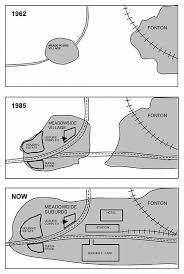
The maps illustrate how Meadowside village and Fonton, which is a neighboring town, have developed over three different time periods (1962, 1985 and the present).
Summarize the information by selecting and reporting the main features, and make comparisons where relevant.
-------------------------------
The pictures illustrate how Meadowside Village and its neighbouring town Fonton have developed since 1962.
It is clear that significant changes have been made in terms of infrastructure, accommodation, and facilities in Meadowside and Fonton area during this period. Both two places expanded their area and subsequently merged into a larger sector.
In 1962, there was only a small road through Meadowside and a railway in Fonton. However, since 1985, the road in Meadowside Village had been reconstructed into a highway, and another main road had been built to connect Meadowside and Fonton. Other additions in recent are the second railway through Fonton, which associate with a new station halfway between two places.
Besides the physical structures mentioned above, by 1985, the new housing and facilities in Meadowside include a housing estate, which had been constructed in the west of the village, and a little close to it was leisure complex. There was also a superstore opposite the housing estate in southern direction. Currently, Meadowside has become a suburbs of Fonton and there are other constructions which have been built in the middle of this combined area. A hotel has been opened to the north of the station, while on the opposite of station to the south is a business park.

download.jpg
