Writing Feedback /
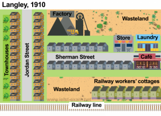
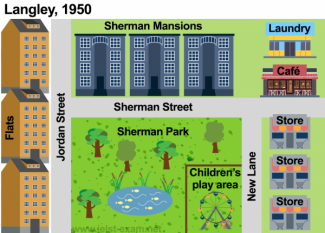
The illustrations detail changes that occurred in the town of Langley from 1910 to 1950 [3]
The maps below show the town of Langley in 1910 and 1950.
Summarise the information by selecting and reporting the main features, and make comparisons where relevant.The illustrations detail changes that occurred in the town of Langley from 1910 to 1950.
From an overall perspective, it is readily apparent that the town has become more commercial with more commercial complexes and stores, and the only areas remaining unchanged are two streets.
As can be seen from the map in 1910, two rows of two houses had been divided two sides by Jordan street in the West area of the town. Moving on, there was Sherman Street, which had separated into North and South areas, in the middle Langley in 1910. A row of residential houses had been built in the North of Sherman Street; store and laundry next to these houses. To the north of the area, the industrial factory had been layout and next to it had been a wasteland. Further, more apartments in the South compared to North had been adjacent to a cafe shop which had been opposite railway workers' cottage with a quite far distance. Also, the accommodation of railway employments had been near to railway line.
We can see the map of Langley in 1950 that it became a commercial town. The row of townhouses was replaced by three flats. In the center of town, the block's apartments were demolished to open Sherman Park and the children's play area. In the east of the town, while old cafe shop was moved to the laundry store's previous position, and the laundry store was reintroduced of the old factory and row of the apartment into Sherman Mansions.

1_88.png

2_16.png


