Diahkn93
Mar 27, 2017
Writing Feedback / New buildings - The maps below show village of Stokeford in 1930 and 2010 [3]
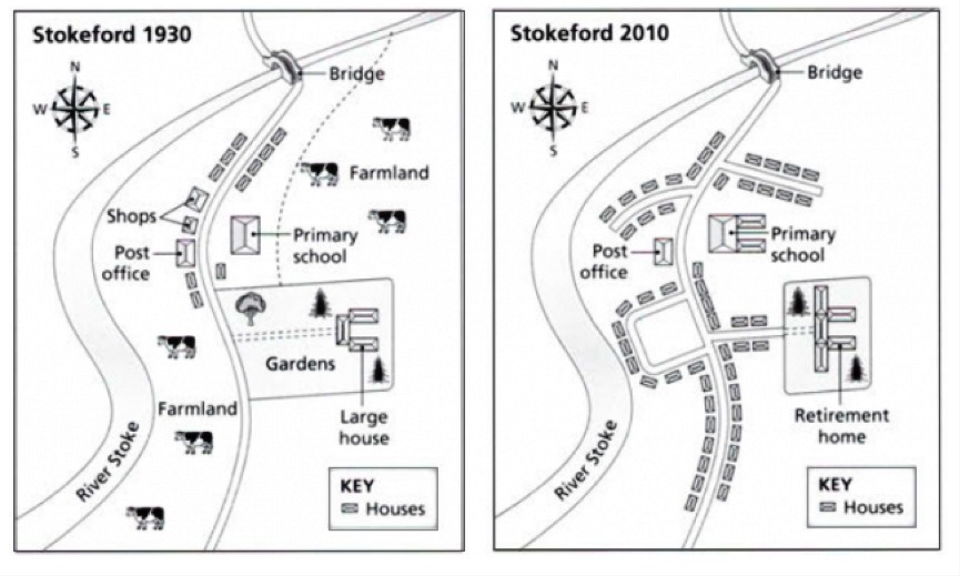
The maps represent of the small print at same city with two difference years. The first map interpret city in year 1930 and in another hand in 2010. For entire 8 periods Stokeford city had developed.
In 1930, farmland had taken over partly of areas which filled in northern and southern areas. Many building such as a shop beside post office and large house settled at far of eastern area of post office. Time by time in 2010 witnessed a dramatic metamorphosis in the number of farmland areas eventually turned over by house in great quantities.
They also eliminate the store and constructed the new buildings such as the expanded primary school and on the south side of the elementary school big house turned into a retirement home. Along with the development of many cities Stokeford has built a new service that allows easy access to the buildings they are made.
1930 vs 2010 in some town
The maps represent of the small print at same city with two difference years. The first map interpret city in year 1930 and in another hand in 2010. For entire 8 periods Stokeford city had developed.
In 1930, farmland had taken over partly of areas which filled in northern and southern areas. Many building such as a shop beside post office and large house settled at far of eastern area of post office. Time by time in 2010 witnessed a dramatic metamorphosis in the number of farmland areas eventually turned over by house in great quantities.
They also eliminate the store and constructed the new buildings such as the expanded primary school and on the south side of the elementary school big house turned into a retirement home. Along with the development of many cities Stokeford has built a new service that allows easy access to the buildings they are made.

WhatsApp_Image_2017.jpeg


